Active Faults of Eurasia Database (AFEAD)
To view fault details - Open the map and click on the fault line. Important information - ! To users.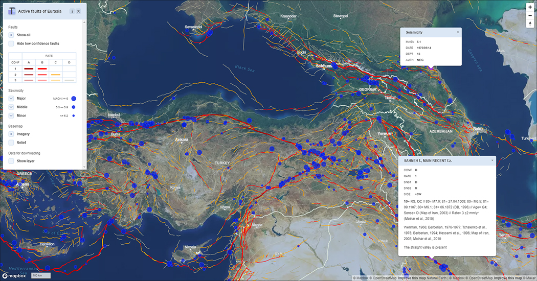
Database presentation on YandexMap
Updated version - AFEAD v.2023 - explanatory information and viewing.
Description of the Database
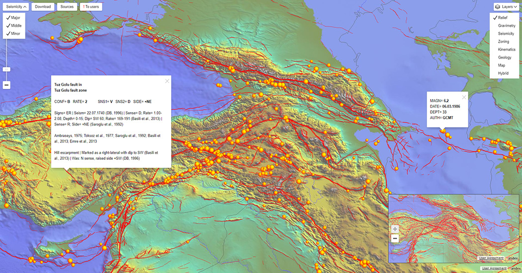
The Active Faults of Eurasia (and Adjacent seas) Database (AFEAD) based on the uniform format ensures integrating the materials accumulated by many researchers, including the authors of the AFEAD. The AFEAD includes the data on more than 20 thousand objects: faults, fault zones and associated structural forms that show the signs of latest displacements in the Late Pleistocene and Holocene. The geographical coordinates are given for each object. The AFEAD working scale is 1:500000; the demonstration scale is 1:1000000.For each object, the AFEAD shows two kinds of characteristics: justification attributes, and estimated attributes. The justification attributes inform the AFEAD user about an object: the object’s name; morphology; kinematics; the amplitudes of displacement for different periods of time; displacement rates estimated from the amplitudes; the age of the latest recorded signs of activity, seismicity and paleoseismicity; the relationship of the given objects with the parameters of crustal earthquakes; etc. The sources of information are listed in the AFEAD appendix.
The estimated attributes are represented by the system of indices reflecting the fault kinematics according to the classification of the faults by types, as accepted in structural geology, and includes three ranks of the Late Quaternary movements and four degrees of reliability of identifying the structures as active ones. With reference to the indices, the objects can be compared with each other, considering any of the attributes, or with any other digitized information. The comparison can be performed by any GIS software.
The AFEAD is an efficient tool for obtaining the information on the faults and solving general problems, such as thematic mapping, determining the parameters of modern geodynamic processes, estimating seismic and other geodynamic hazards, identifying the tectonic development trends in the Pliocene–Quaternary stage of the Earth's development, etc. The Active Faults of Eurasia Database is created in the format providing for inputs of new information, as well the database revision.
Explanatory note to the Active Fault of Eurasia Database (description of the content and compilation methodology)
Supplementary information
Link to the publication describing the current version Active Faults of Eurasia Database - AFEAD v2022:Zelenin E.A, Bachmanov D.M., Garipova S.T., Trifonov V.G., Kozhurin A.I. The Active Faults of Eurasia Database (AFEAD): the ontology and design behind the continental-scale dataset // Earth System Science Data. 2022. vol. 14. p. 4489-4503.
A list of links to sources of information used in compiling the Active Faults of Eurasia Database